Atlantic City Airport (ACY) | Terminal maps | Airport guide


Atlantic City Airport Terminal Guides
View All ACY Guides-
ACY Airport Terminal
Open Guide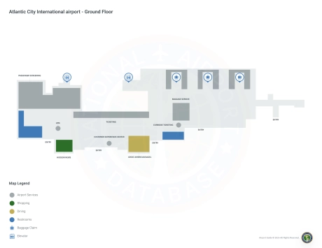
Atlantic City Airport Information
-
Airport Address:
101 Atlantic City International Airport, Egg Harbor Twp, NJ 08234, United States -
Official Website:
http://www.sjta.com/acairport/ -
Contact Number:
(888) 235-9229
ACY Contact Information
-
Name:
TIM KROLL -
Address:
SUITE 100 -
Telephone:
(609) 645-7895
Atlantic City Airport
Atlantic City International Airport (ACY), located in Egg Harbor Township, New Jersey, is a critical gateway to the famous resort city of Atlantic City and other areas of southern New Jersey. This airport is strategically positioned to serve both leisure and business travelers, offering direct access to one of the East Coast's most popular entertainment destinations.
Served primarily by Spirit Airlines, ACY Airport provides direct flights to major cities such as Orlando, Fort Lauderdale, Tampa, Fort Myers, Myrtle Beach and others. This connection is critical to boost tourism and business travel to Atlantic City, known for its casinos, beaches and waterfront.
The ACY terminal is equipped with an array of amenities designed to enhance the passenger experience. Amenities include restaurants to grab a bite to eat, retail stores offering travel goods and souvenirs, and free Wi-Fi to help passengers stay connected. For added passenger convenience, the airport offers ample parking, on-site car rental services, and cab and ride-sharing services, providing easy transportation to and from the airport.
Atlantic City International Airport plays an important role for travelers by offering a convenient and efficient transportation option that supports the region's tourism industry and provides vital connectivity for residents and visitors. Its strategic location combined with focused service makes ACY an important hub for New Jersey's transportation infrastructure.
Atlantic City Airport Weather 08/02/2026
Weather Forecast
This Afternoon
84
Slight Chance Showers
Tonight
74
Heavy Rain

Monday
83
Heavy Rain

Monday Night
66
Heavy Rain

Tuesday
84
Partly Sunny
Tuesday Night
67
Mostly Cloudy then Slight Chance Showers

Wednesday
85
Chance Showers

Wednesday Night
71
Mostly Cloudy
Thursday
88
Mostly Sunny then Chance Showers

Thursday Night
73
Chance Showers
Friday
89
Mostly Sunny then Chance T-storms
Friday Night
72
Chance T-storms then Chance Showers
Saturday
89
Mostly Sunny then Chance Showers