Columbia Airport (CAE) | Terminal maps | Airport guide


Columbia Airport Terminal Guides
View All CAE Guides-
CAE Airport Terminal
Open Guide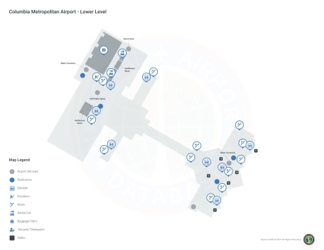
Columbia Airport Information
-
Airport Address:
3250 Airport Blvd, West Columbia, SC 29170, United States -
Official Website:
http://www.columbiaairport.com/ -
Contact Number:
(803) 822-5000
CAE Contact Information
-
Name:
MICHEAL GULA -
Address:
3250 AIRPORT BLVD, SUITE 10 -
Telephone:
(803) 822-5017
Columbia Airport
Columbia Metropolitan Airport (CAE), located in West Columbia, South Carolina, is a key regional airport serving the state's capital and surrounding areas. It's situated about 5 miles southwest of downtown Columbia, offering convenient access via Interstate 26. The airport features a single terminal, designed for ease of navigation and efficiency. CAE hosts several major airlines, including American Airlines, Delta Air Lines, and United Airlines, providing direct and connecting flights primarily to major hubs like Atlanta, Charlotte, and Dallas/Fort Worth. The airport offers essential amenities such as dining options, car rentals, and free Wi-Fi, ensuring a comfortable experience for both business and leisure travelers. With its modern facilities and southern charm, Columbia Metropolitan Airport offers a pleasant and hassle-free gateway to South Carolina.
Columbia Airport Weather 08/03/2026
Weather Forecast
Overnight
73
Slight Chance Showers
Monday
89
Slight Chance T-storms then Chance Showers
Monday Night
73
Slight Chance T-storms then Chance Showers
Tuesday
90
Chance Showers then T-storms Likely
Tuesday Night
73
T-storms Likely then Chance Showers

Wednesday
90
Showers Likely
Wednesday Night
73
Showers Likely then Partly Cloudy
Thursday
91
Mostly Sunny then Chance T-storms

Thursday Night
73
Chance T-storms
Friday
92
Mostly Sunny then Chance T-storms
Friday Night
73
Chance T-storms then Partly Cloudy
Saturday
90
Mostly Sunny then Chance T-storms

Saturday Night
73
Chance T-storms