Gainesville Airport (GNV) | Terminal maps | Airport guide


Gainesville Airport Terminal Guides
View All GNV Guides-
GNV Airport Terminal
Open Guide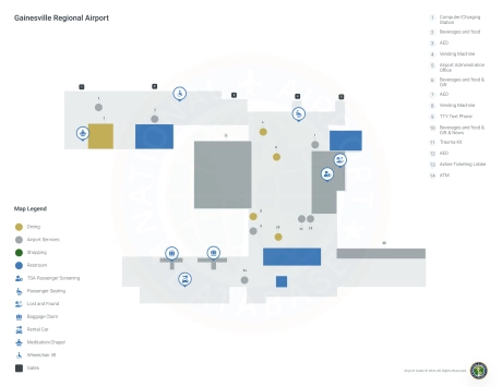
Gainesville Airport Information
-
Airport Address:
3880 NE 39th Ave, Gainesville, FL 32609, United States -
Official Website:
http://www.gra-gnv.com/ -
Contact Number:
(352) 373-0249
GNV Contact Information
-
Name:
ALLAN PENKSA -
Address:
3880 NE 39 AVE STE A -
Telephone:
(352) 373-0249
Gainesville Airport
Gainesville Regional Airport (GNV), located in Gainesville, Florida, serves as a key gateway to North Central Florida, home to the University of Florida.
The airport is served by major airlines such as American Airlines, Delta Air Lines and United Airlines, providing direct flights to important hubs such as Atlanta, Charlotte, Miami and Dallas/Fort Worth. This connectivity provides passengers with convenient access to onward domestic and international destinations.
The GNV terminal is equipped with amenities designed to enhance the passenger experience, including restaurants for meals and snacks, car rental services for conveniently exploring the region, and free Wi-Fi to keep travelers connected. Parking lots are easily accessible and conveniently located near the terminal, ensuring a smooth and efficient travel experience for all passengers. GNV's amenities and services make it an indispensable hub for travelers in and around Gainesville.
Gainesville Airport Weather 08/02/2026
Weather Forecast
Overnight
76
Chance Showers
Sunday
86
Showers Likely then T-storms

Sunday Night
74
T-storms Likely
Monday
87
Showers then T-storms
Monday Night
72
Slight Chance T-storms then Chance Showers

Tuesday
91
Showers Likely
Tuesday Night
72
Chance Showers then Mostly Cloudy
Wednesday
93
Mostly Sunny then T-storms Likely
Wednesday Night
72
T-storms Likely then Slight Chance T-storms
Thursday
93
Slight Chance T-storms then Chance T-storms

Thursday Night
73
Chance T-storms
Friday
92
Chance T-storms then T-storms Likely
Friday Night
72
T-storms Likely then Slight Chance T-storms