Lawton-Fort Sill Regional Airport (LAW)

Lawton-Fort Sill Airport Weather
Learn MoreTonight
62
Clear
Tuesday
91
Sunny
Tuesday Night
62
Clear
Wednesday
93
Sunny
Wednesday Night
63
Clear
Thursday
94
Sunny
Thursday Night
66
Clear
Friday
93
Sunny
Friday Night
67
Mostly Clear
Saturday
90
Sunny
Saturday Night
66
Mostly Clear
Sunday
90
Sunny
Sunday Night
64
Mostly Clear
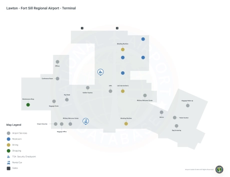
Lawton-Fort Sill Airport Information
Airport Address:
3401 SW 11th St., Lawton, OK 73501, United States
Official Website:
Contact Number:
Airnav link:
LAW Manager & Contact Information
About Lawton-Fort Sill Airport
Lawton is a city in, and the county seat of, Comanche County, in the U. S. state of Oklahoma. Located in southwestern Oklahoma, approximately 87 mi (140 km) southwest of Oklahoma City, it is the principal city of the Lawton, Oklahoma, metropolitan statistical area. According to the 2010 census, Lawton's population was 96,867, making it the fifth-largest city in the state, and the largest in Western Oklahoma. Developed on former reservation lands of the Kiowa, Comanche, and Apache Indians, Lawton was founded by European Americans on 6 August 1901. It was named after Major General Henry Ware Lawton, who served in the Civil War, where he earned the Medal of Honor, and was killed in action in the Philippine American War. Lawton's landscape is typical of the Great Plains, with flat topography and gently rolling hills, while the area north of the city is marked by the Wichita Mountains. The city's proximity to the Fort Sill Military Reservation, formerly the base of the Apache territory before statehood, gave Lawton economic and population stability throughout the 20th century. Although Lawton's economy is still largely dependent on Fort Sill, it has grown to encompass manufacturing, higher education, health care, and retail. The city has a council-manager government; the city council members are elected from single-member districts and the mayor is elected at-large. They hire a professional city manager to direct daily operations. Interstate 44 and three major United States highways serve the city, while Lawton-Fort Sill Regional Airport connects Lawton by air. Recreation can be found at the city's many parks, lakes, museums, and festivals. Notable residents of the city include many musical and literary artists, as well as several professional athletes.
Lawton-Fort Sill Airport Maps
LAW Airport map
LAW Airport diagram
Lawton-Fort Sill Airport Ground Transportation
Learn MoreLawton-Fort Sill Airport Rental Cars
Learn MoreLawton-Fort Sill Airport Parking
Learn MoreLawton-Fort Sill Airport Hotels
Learn MoreLAW Charts & Navaids
Learn More
Latitude:
37-37-07.7000N (37.618806)
Longitude:
122-22-31-5000W (-122.375417)
Elevation:
13.1 feet MSL (4 m MSL)
Magnetic Variation:
13.2 E (as of March 2022 from WMM2020 model)
Time Zone:
UTC -8.0 (Standard Time)
UTC -7.0 (Daylight Savings Time)
From City:
08 N.M. SE of San Francisco, California
Found On:
San Francisco Chart
FAA Region:
AWP