Lake Charles Airport (LCH) | Terminal maps | Airport guide


Lake Charles Airport Terminal Guides
View All LCH Guides-
LCH Airport Terminal
Open Guide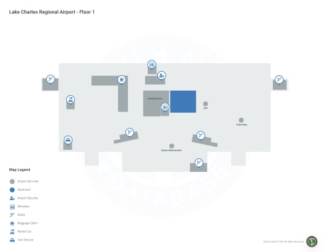
Lake Charles Airport Information
-
Airport Address:
500 Airport Blvd #104, Lake Charles, LA 70607, United States -
Official Website:
http://www.flylakecharles.com/ -
Contact Number:
(337) 477-6051
LCH Contact Information
-
Name:
HEATH ALLEN -
Address:
PO DRAWER 5820 -
Telephone:
(337) 477-6051
Lake Charles Airport
Lake Charles Regional Airport (LCH), located in Lake Charles, Louisiana, is served by American Airlines and United Airlines, offering direct flights to major hubs such as Dallas/Fort Worth and Houston. This enhances domestic and international connections. The terminal provides essential amenities including parking, car rental services for ease of getting around the region, and cab services. LCH plays an important role for travelers by contributing to the economic development of Southwest Louisiana by supporting tourism and business travel, as well as offering a convenient travel option for residents and visitors.
Lake Charles Airport Weather 08/03/2026
Weather Forecast
Today
96
Sunny

Tonight
78
Mostly Clear
Tuesday
94
Sunny then Slight Chance T-storms
Tuesday Night
78
Mostly Clear
Wednesday
94
Sunny then Slight Chance T-storms
Wednesday Night
78
Mostly Clear
Thursday
93
Sunny then Chance T-storms
Thursday Night
77
Partly Cloudy then Slight Chance T-storms

Friday
93
Chance T-storms
Friday Night
77
Mostly Clear
Saturday
93
Sunny then Chance T-storms
Saturday Night
77
Partly Cloudy then Slight Chance T-storms
Sunday
92
Chance T-storms then T-storms Likely