MBS International Airport (MBS) | Terminal maps | Airport guide


MBS International Airport Terminal Guides
View All MBS Guides-
MBS Airport Terminal
Open Guide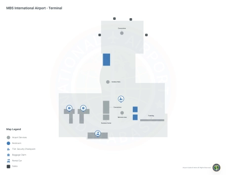
MBS International Airport Information
-
Airport Address:
8500 Garfield Rd, Freeland, MI 48623, United States -
Official Website:
http://www.mbsairport.org/ -
Contact Number:
(989) 695-5555
MBS Contact Information
-
Name:
JEFF NAGEL -
Address:
8500 GARFIELD RD STE 101 -
Telephone:
(989) 695-5555
MBS International Airport
MBS International Airport (MBS), located in Freeland, Michigan, serves the Midland, Bay City, and Saginaw region, acting as a vital link for travelers in the Tri-Cities area. It is served by major airlines such as United Airlines and Delta Air Lines, offering direct flights to hubs like Chicago and Detroit, thereby facilitating easy access to national and international destinations.
The terminal at MBS provides a range of amenities to ensure a comfortable travel experience, including ample parking, car rental services for convenient regional travel, and taxi services for easy airport access. Additional facilities include dining options and free Wi-Fi.
MBS International Airport is crucial for travelers for its strategic location, offering efficient connectivity and supporting the economic development of the Tri-Cities area. It caters to the needs of both business and leisure travelers, making it an essential hub for the region and enhancing the accessibility to and from Central Michigan.
MBS International Airport Weather 07/23/2026
Weather Forecast
Overnight
50
Clear

Thursday
77
Sunny

Thursday Night
55
Mostly Clear

Friday
79
Sunny
Friday Night
58
Mostly Clear

Saturday
82
Mostly Sunny
Saturday Night
65
Partly Cloudy then Showers Likely
Sunday
85
Showers Likely then Mostly Sunny

Sunday Night
63
Chance Showers
Monday
83
Chance Showers then Chance T-storms
Monday Night
63
Chance T-storms then Chance Showers
Tuesday
81
Mostly Sunny
Tuesday Night
60
Mostly Clear