Albert J Ellis Airport (OAJ) | Terminal maps | Airport guide


Albert J Ellis Airport Terminal Guides
View All OAJ Guides-
OAJ Airport Terminal
Open Guide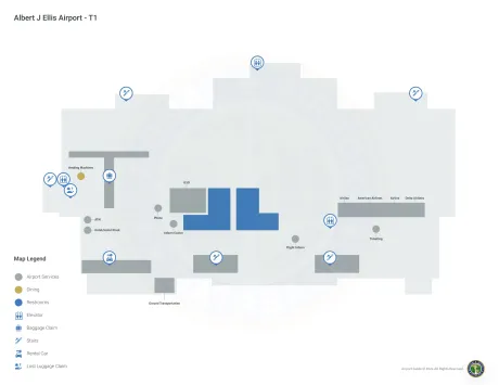
Albert J Ellis Airport Information
-
Airport Address:
264 State Road 1265, Richlands, NC 28574, United States -
Official Website:
http://www.flyoaj.com/ -
Contact Number:
(910) 324-1100
OAJ Contact Information
-
Name:
CHRISTOPHER WHITE -
Address:
264 ELLIS AIRPORT RD -
Telephone:
(910) 324-1100
Albert J Ellis Airport
Albert J. Ellis Airport (OAJ), located near Jacksonville, North Carolina, serves as a critical link between the military town of Camp Lejeune, the city of Jacksonville and other parts of Onslow County.
The airport is served by major airlines such as American Airlines and Delta Air Lines, offering direct flights to hubs such as Charlotte and Atlanta, thereby giving passengers access to an extensive national and international network.
The OAJ terminal is designed with travelers in mind and offers amenities such as parking, car rentals for conveniently moving around the region and cab services for local transportation. Additional amenities include restaurants, free Wi-Fi and comfortable waiting areas.
Albert J. Ellis Airport plays a critical role in supporting the local economy, facilitating military travel, enhancing accessibility to North Carolina's coastal areas and providing important air service for residents, military personnel and visitors. With its strategic location and wide range of services, OAJ Airport is an important gateway to promote connectivity and economic development in Jacksonville and Onslow County.
Albert J Ellis Airport Weather 07/23/2026
Weather Forecast
This Afternoon
87
T-storms Likely
Tonight
72
T-storms then Showers
Friday
85
Showers then T-storms
Friday Night
69
T-storms then Showers Likely

Saturday
86
Showers

Saturday Night
68
Showers Likely
Sunday
88
Chance Showers then Chance T-storms
Sunday Night
67
Chance T-storms then Partly Cloudy

Monday
91
Mostly Sunny

Monday Night
71
Mostly Clear

Tuesday
95
Sunny

Tuesday Night
73
Chance T-storms
Wednesday
93
Mostly Sunny then Chance T-storms