Albany Airport (ALB) | Terminal maps | Airport guide


Albany Airport Terminal Guides
View All ALB Guides-
ALB Airport Terminal
Open Guide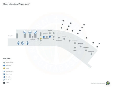
Albany Airport Information
-
Airport Address:
737 Albany Shaker Rd, Albany, NY 12211, United States -
Official Website:
http://www.albanyairport.com/ -
Contact Number:
(518) 242-2200
ALB Contact Information
-
Name:
FRED ACUNTO -
Address:
737 ALBANY SHAKER ROAD -
Telephone:
(518) 242-2352
Albany Airport
Albany International Airport (ALB), located in Albany, New York, serves as a key transportation hub for the Capital Region, Saratoga County and the Adirondack Region. Strategically located just a few miles northwest of downtown Albany, it offers a convenient gateway for both business and leisure travelers.
ALB is served by several major airlines, including American Airlines, United Airlines, Delta Air Lines, Southwest Airlines, JetBlue and Frontier Airlines. These carriers provide passengers with many direct flight options to major U.S. cities such as New York, Chicago, Atlanta, Orlando, Denver and more. This extensive network allows for easy access to international destinations as well.
The airport has a modern terminal with a wide range of passenger amenities. Travelers can enjoy a selection of dining establishments, from quick-service to full-service restaurants, as well as retail stores offering everything from books and electronics to gifts and travel supplies. Additional amenities include free Wi-Fi throughout the terminal, electronic device charging stations and comfortable lounge areas for relaxing. For added convenience, Albany International Airport provides ample parking, car rental services and efficient public transportation options to ensure a smooth and seamless journey for all visitors.
Albany Airport Weather 07/28/2026
Weather Forecast
This Afternoon
81
Showers

Tonight
63
Showers

Wednesday
72
Showers

Wednesday Night
60
Showers

Thursday
76
Showers Likely
Thursday Night
59
Chance Showers then Mostly Cloudy

Friday
81
Mostly Sunny

Friday Night
61
Mostly Clear
Saturday
84
Mostly Sunny

Saturday Night
65
Mostly Cloudy
Sunday
81
Partly Sunny then Chance Showers

Sunday Night
65
Chance Showers
Monday
80
Mostly Cloudy then Chance Showers