Baton Rouge Airport (BTR) | Terminal maps | Airport guide


Baton Rouge Airport Terminal Guides
View All BTR Guides-
BTR Airport Terminal
Open Guide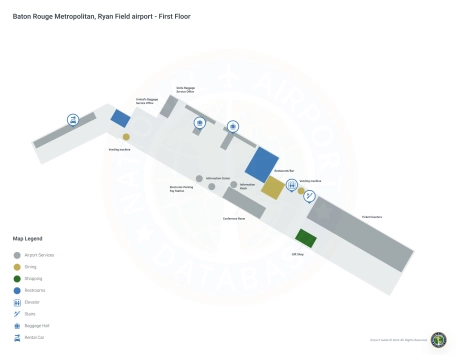
Baton Rouge Airport Information
-
Airport Address:
9430 Jackie Cochran Dr, Baton Rouge, LA 70811, United States -
Official Website:
http://www.flybtr.com/ -
Contact Number:
(225) 355-0333
BTR Contact Information
-
Name:
MIKE EDWARDS -
Address:
9430 JACKIE COCHRAN DR. STE 300 -
Telephone:
(225) 355-0333
Baton Rouge Airport
Baton Rouge Metropolitan Airport (Ryan Field) (BTR), located in Baton Rouge, Louisiana, serves as a critical link between the metropolitan area and major U.S. cities.
The airport is served by major airlines including American Airlines, Delta Air Lines and United Airlines, offering direct flights to key hubs such as Dallas/Fort Worth, Atlanta and Houston. This provides seamless travel for both business and leisure travelers to national and international destinations.
The BTR terminal is equipped with many amenities to ensure a comfortable traveling experience. These include restaurants, car rentals conveniently located within the airport, cab stands and ride-sharing services for the convenience of travelers. There is ample parking with short-term and long-term parking options.
The Baton Rouge Metropolitan Airport is important to travelers for its accessibility, providing access to the Gulf Coast region and beyond. It supports the local economy through tourism and business travel, making it an important infrastructure asset for Baton Rouge and surrounding areas.
Baton Rouge Airport Weather 07/19/2026
Weather Forecast
Today
97
Hot

Tonight
77
Partly Cloudy
Monday
98
Hot

Monday Night
78
Mostly Clear
Tuesday
98
Sunny then Slight Chance T-storms
Tuesday Night
78
Mostly Clear
Wednesday
98
Hot
Wednesday Night
77
Partly Cloudy
Thursday
97
Sunny then Slight Chance T-storms

Thursday Night
76
Slight Chance T-storms

Friday
97
Slight Chance T-storms
Friday Night
76
Partly Cloudy
Saturday
94
Chance T-storms