Jacksonville Airport (JAX) | Terminal maps | Airport guide


Jacksonville Airport Terminal Guides
View All JAX Guides-
JAX Airport Concourse A
Open Guide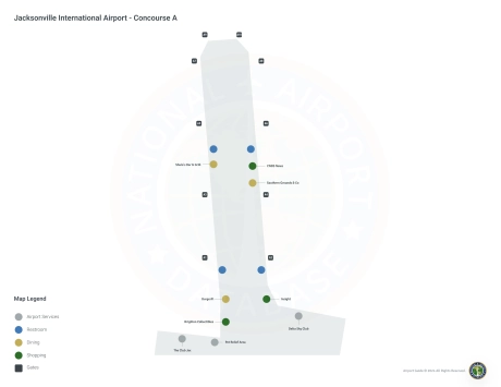
-
JAX Airport Concourse C
Open Guide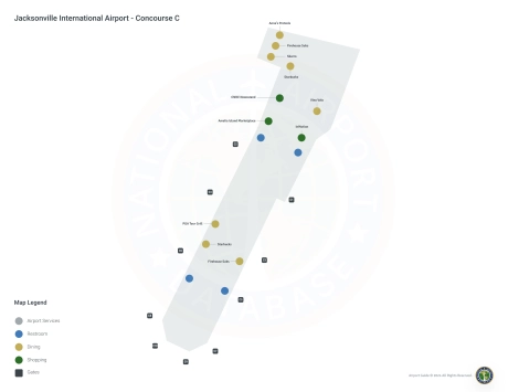
-
JAX Airport Terminal
Open Guide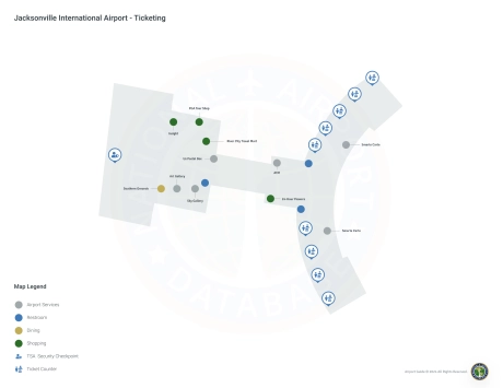
Jacksonville Airport Information
-
Airport Address:
2400 Yankee Clipper Dr, Jacksonville, FL 32218, United States -
Official Website:
http://www.flyjacksonville.com/default.aspx?sMP=JIA -
Contact Number:
(904) 741-4902
JAX Contact Information
-
Name:
MR. TERRY DLUGOS -
Address:
14201 PECAN PARK ROAD -
Telephone:
(904) 741-3866
Jacksonville Airport
Jacksonville International Airport (JAX), strategically located in Jacksonville, Florida, serves as a key gateway to the Northeast Florida region.
This busy airport serves a wide range of passengers, offering flights from several major airlines including American Airlines, Delta Air Lines, Southwest Airlines, United Airlines, JetBlue, and Frontier Airlines. These carriers provide direct flights to many major U.S. cities such as Atlanta, Dallas, New York, Chicago, Denver and others, facilitating both national and international travel through connecting flights.
JAX Airport features a modern and comfortable terminal with a wide range of amenities designed to enhance the passenger experience. Amenities include a variety of restaurants to suit different tastes, retail outlets offering everything from books to luxury goods, free Wi-Fi throughout the terminal, comfortable lounges and even art exhibitions showcasing local culture. For added convenience, the airport offers many parking options, including short-term, long-term and economy parking, as well as a comprehensive car rental center located on the airport grounds. Cab and ride-sharing services are available at the airport, providing efficient ground transportation for travelers.
Jacksonville International Airport plays an important role for travelers as a critical access point to the city and surrounding area, supporting tourism, business travel, and local economic development. With its strategic location, wide range of flights and passenger-oriented amenities, JAX is an indispensable hub for Northeast Florida residents and visitors, providing connectivity and accessibility to this vibrant region.
Jacksonville Airport Weather 08/01/2026
Weather Forecast
This Afternoon
91
T-storms Likely
Tonight
74
Chance T-storms then Slight Chance Showers
Sunday
88
Chance T-storms then T-storms
Sunday Night
75
Chance T-storms then Chance Showers
Monday
89
Chance T-storms then T-storms
Monday Night
74
T-storms then Mostly Cloudy
Tuesday
92
Slight Chance T-storms then T-storms Likely
Tuesday Night
75
T-storms Likely then Slight Chance T-storms
Wednesday
92
Mostly Sunny then Chance T-storms
Wednesday Night
75
Chance T-storms then Partly Cloudy

Thursday
91
Chance T-storms
Thursday Night
75
Chance T-storms then Partly Cloudy

Friday
92
Chance T-storms