Sioux Falls Airport (FSD) | Terminal maps | Airport guide


Sioux Falls Airport Terminal Guides
View All FSD Guides-
FSD Airport Terminal
Open Guide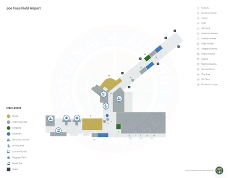
Sioux Falls Airport Information
-
Airport Address:
2801 N Jaycee Ln, Sioux Falls, SD 57104, United States -
Official Website:
http://www.sfairport.com/ -
Contact Number:
(605) 336-0762
FSD Contact Information
-
Name:
DANIEL J. LETELLIER -
Address:
2801 JAYCEE LANE -
Telephone:
(605) 336-0762
Sioux Falls Airport
Joe Foss Field Airport (FSD), located in Sioux Falls, South Dakota, is a major aviation center for the southeastern part of the state and the surrounding region.
This airport is served by several major airlines, including American Airlines, Delta Air Lines, Frontier Airlines, Allegiant Air, and United Airlines. These carriers offer direct flights to major hubs and popular destinations such as Denver, Las Vegas, Chicago, Minneapolis, Phoenix, Dallas and more, providing convenient connections for both domestic and international travel.
The Joe Foss Field airport terminal is designed to provide travelers with a smooth and efficient operation. It boasts an array of amenities designed to enhance passenger comfort and convenience, including restaurants to suit every taste, retail outlets, and car rental services for easy access to Sioux Falls and beyond. The airport also offers free Wi-Fi, allowing passengers to stay connected. With ample parking and a convenient layout, FSD effectively serves as the region's most important transportation hub, meeting the travel needs of residents and visitors alike.
Sioux Falls Airport Weather 07/16/2026
Weather Forecast
Today
92
Sunny

Tonight
72
Mostly Clear

Friday
96
Hot
Friday Night
72
Mostly Clear
Saturday
92
Sunny
Saturday Night
67
Mostly Clear
Sunday
95
Hot

Sunday Night
73
Chance T-storms
Monday
95
Hot
Monday Night
67
Mostly Clear

Tuesday
87
Mostly Sunny

Tuesday Night
63
Partly Cloudy

Wednesday
84
Partly Sunny