Capital Region Airport (LAN) | Terminal maps | Airport guide


Capital Region Airport Terminal Guides
View All LAN Guides-
LAN Airport Terminal
Open Guide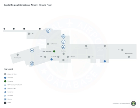
Capital Region Airport Information
-
Airport Address:
4100 Capital City Blvd, Lansing Charter Township, MI 48906, United States -
Official Website:
http://www.flylansing.com/ -
Contact Number:
(517) 321-6121
LAN Contact Information
-
Name:
ROBERT BENSTEIN -
Address:
4100 CAPITAL CITY BLVD -
Telephone:
(517) 886-3716
Capital Region Airport
The Capital Region International Airport (LAN), located in Lansing, Michigan, serves as a critical gateway to the Michigan Capital Region, offering an alternative to the state's busier airports.
The airport is served by major airlines such as American Airlines and Delta Air Lines, providing direct flights to key hubs such as Chicago and Detroit, exposing travelers to a wide network of national and international destinations.
The LAN terminal is equipped with a variety of amenities to ensure a comfortable travel experience for passengers, including parking, car rental services for convenient travel throughout the region, and cab services for convenient local transportation. Additional services include meals and free Wi-Fi.
The Capital Region International Airport is very important to travelers due to its strategic location that provides convenient access to government, education, and business centers in and around Lansing.
Capital Region Airport Weather 07/23/2026
Weather Forecast
Overnight
50
Clear

Thursday
78
Sunny

Thursday Night
55
Partly Cloudy

Friday
81
Sunny

Friday Night
57
Mostly Clear

Saturday
84
Mostly Sunny
Saturday Night
66
Partly Cloudy then Chance T-storms
Sunday
89
Chance T-storms then Mostly Sunny

Sunday Night
64
Chance T-storms

Monday
87
Chance T-storms

Monday Night
64
Chance Showers
Tuesday
84
Sunny
Tuesday Night
60
Mostly Clear