La Crosse Airport (LSE) | Terminal maps | Airport guide


La Crosse Airport Terminal Guides
View All LSE Guides-
LSE Airport Terminal
Open Guide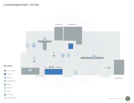
La Crosse Airport Information
-
Airport Address:
2850 Airport Dr, La Crosse, WI 54603, United States -
Official Website:
http://www.lseairport.com/ -
Contact Number:
(608) 789-7464
LSE Contact Information
-
Name:
IAN TURNER -
Address:
2850 AIRPORT ROAD -
Telephone:
(608) 789-7456
La Crosse Airport
La Crosse Regional Airport (LSE), located in La Crosse, Wisconsin, is a key connection for the region. It is served by major airlines such as American Airlines, Delta Air Lines, and Sun Country Airlines. These carriers offer direct flights to hubs such as Chicago, Minneapolis, and seasonal destinations, which enhances travel connections.
The terminal offers amenities such as parking, rental cars for regional travel, and cabs.
LSE plays an important role for travelers by expanding access to the Upper Midwest, supporting local tourism and businesses, and serving as an important connection for residents and visitors.
La Crosse Airport Weather 08/03/2026
Weather Forecast
Tonight
62
Clear

Monday
83
Sunny

Monday Night
65
Increasing Clouds

Tuesday
82
Chance Showers

Tuesday Night
60
Chance T-storms

Wednesday
79
Mostly Sunny
Wednesday Night
58
Partly Cloudy

Thursday
82
Sunny

Thursday Night
61
Mostly Clear
Friday
84
Mostly Sunny

Friday Night
64
Slight Chance T-storms
Saturday
85
Sunny
Saturday Night
67
Slight Chance T-storms then Chance Showers