Appleton Airport (ATW) | Terminal maps | Airport guide


Appleton Airport Terminal Guides
View All ATW Guides-
ATW Airport Terminal
Open Guide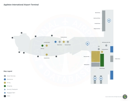
Appleton Airport Information
-
Airport Address:
W6390 Challenger Dr, Appleton, WI 54914, United States -
Official Website:
http://www.atwairport.com/ -
Contact Number:
(920) 832-5268
ATW Contact Information
-
Name:
ABE WEBER, AIRPORT DIRECTOR -
Address:
W6390 CHALLENGER DR-SUITE 201 -
Telephone:
(920) 832-5267
Appleton Airport
Appleton International Airport (ATW), strategically located in Greenville, Wisconsin, a stone's throw from Appleton, serves as a critical gateway to the Fox Cities region. It caters to a wide range of travelers and serves airlines such as American Airlines, Delta Air Lines, United Airlines, and Allegiant Air. These carriers offer direct flights to key hubs and popular destinations such as Chicago, Atlanta, Minneapolis, Orlando and Las Vegas, making domestic and leisure travel very affordable.
The ATW terminal is designed with passenger comfort in mind and includes many amenities. It offers travelers a variety of restaurants, from quick snacks to more relaxed meals, as well as car rentals right on the airport grounds for convenient transportation around the city. The airport provides internet connectivity thanks to free Wi-Fi, and a children's playground is available for families. Additional amenities include a gift store, ample and accessible parking near the terminal, and simplified security procedures - all designed to ensure a smooth and enjoyable journey for visitors and residents alike.
Appleton Airport Weather 07/20/2026
Weather Forecast
This Afternoon
86
Chance T-storms
Tonight
67
Severe Thunderstorms then Patchy Smoke

Tuesday
79
Mostly Sunny

Tuesday Night
55
Mostly Clear

Wednesday
75
Sunny
Wednesday Night
56
Mostly Clear
Thursday
80
Sunny
Thursday Night
61
Mostly Clear
Friday
80
Sunny
Friday Night
63
Mostly Clear
Saturday
84
Sunny
Saturday Night
67
Mostly Clear then Slight Chance Showers
Sunday
88
Mostly Sunny then Slight Chance T-storms