Austin-Bergstrom Airport (AUS) | Terminal maps | Airport guide


Austin-Bergstrom Airport Terminal Guides
View All AUS Guides-
AUS Airport Terminal
Open Guide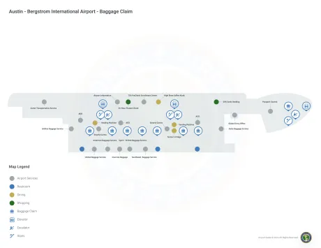
-
AUS Airport South Terminal
Open Guide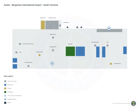
Austin-Bergstrom Airport Information
-
Airport Address:
3600 Presidential Blvd, Austin, TX 78719, United States -
Official Website:
http://www.austintexas.gov/airport -
Contact Number:
(512) 530-2242
AUS Contact Information
-
Name:
JACQUELINE YAFT -
Address:
3600 PRESIDENTIAL BLVD, SUITE 411 -
Telephone:
(512) 530-2242
Austin-Bergstrom Airport
Austin-Bergstrom International Airport (AUS), located in Austin, Texas, is a critical access point to the city's vibrant culture and booming technology scene. Served by a wide range of airlines including American, Delta, Southwest, United and international carriers such as British Airways, AUS offers direct flights to key U.S. cities, Mexico, Canada and Europe. The airport consists of the Barbara Jordan Terminal and the South Terminal, equipped with amenities such as a variety of restaurants reflecting Austin's culinary scene, retail stores, free Wi-Fi, lounges and local art exhibits. The airport's importance to travelers lies in its comprehensive service, global connectivity and embodiment of Austin's welcoming spirit, making it an important hub for both leisure and business travelers looking to explore Austin or make global connections.
Austin-Bergstrom Airport Weather 07/18/2026
Weather Forecast
Today
94
Partly Sunny

Tonight
75
Increasing Clouds
Sunday
95
Gradual Clearing

Sunday Night
74
Mostly Clear

Monday
95
Sunny

Monday Night
73
Clear
Tuesday
96
Sunny
Tuesday Night
74
Clear
Wednesday
96
Sunny
Wednesday Night
76
Mostly Clear
Thursday
96
Sunny
Thursday Night
76
Mostly Clear
Friday
96
Sunny