Durango La Plata County Airport (DRO) | Terminal maps | Airport guide


Durango La Plata County Airport Terminal Guides
View All DRO Guides-
DRO Airport Terminal
Open Guide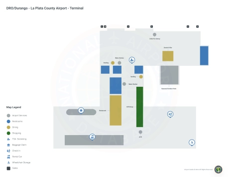
Durango La Plata County Airport Information
-
Airport Address:
1000 Airport Rd, Durango, CO 81303, United States -
Official Website:
https://www.flydurango.com/1748/Airport -
Contact Number:
(970) 382-6050
DRO Contact Information
-
Name:
ANTHONY VICARI - DIR OF AVIATION -
Address:
1000 AIRPORT ROAD BOX 15 -
Telephone:
(970) 382-6051
Durango La Plata County Airport
Durango-La Plata County Airport (DRO), located in the scenic environs of Durango, Colorado, is the primary aviation gateway to the Four Corners region, offering access to the breathtaking scenery and outdoor adventures of southwestern Colorado.
Several major airlines including American Eagle, United Airlines and United Express fly from this airport, providing direct connections to key centers such as Dallas/Fort Worth, Denver and Phoenix. These routes allow passengers to travel seamlessly throughout the United States and beyond.
The DRO terminal is designed to reflect the natural beauty of its surroundings, providing a welcoming and efficient space for travelers. Within the terminal, passengers can take advantage of a variety of amenities designed to enhance their airport experience. These include restaurants where local cuisine can be sampled, retail outlets where last-minute souvenirs can be purchased, and free Wi-Fi to keep travelers connected at all times. The airport places a strong emphasis on accessibility so that all passengers, including those with disabilities, can move around the area comfortably. In addition to these passenger services, the Durango-La Plata County Airport offers convenient parking lots located near the terminal. For added convenience, car rental agencies, cab and ride-sharing services are available here so that travelers can easily reach their final destinations in the surrounding area.
The combination of strategic location, amenities and customer care makes DRO Airport a vital hub for accessing the natural and cultural riches of the region.
Durango La Plata County Airport Weather 08/02/2026
Weather Forecast
This Afternoon
96
Sunny

Tonight
56
Mostly Clear

Monday
97
Hot
Monday Night
55
Mostly Clear
Tuesday
96
Sunny
Tuesday Night
57
Mostly Clear
Wednesday
95
Sunny
Wednesday Night
56
Mostly Clear
Thursday
95
Sunny
Thursday Night
55
Mostly Clear
Friday
96
Sunny
Friday Night
58
Mostly Clear
Saturday
95
Sunny