Hector Airport (FAR) | Terminal maps | Airport guide


Hector Airport Terminal Guides
View All FAR Guides-
FAR Airport Terminal
Open Guide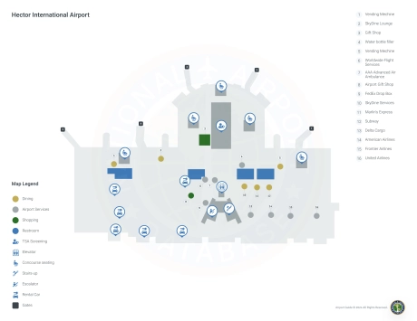
Hector Airport Information
-
Airport Address:
2801 32nd Ave NW, Fargo, ND 58102, United States -
Official Website:
http://www.fargoairport.com/ -
Contact Number:
(701) 241-8168
FAR Contact Information
-
Name:
SHAWN DOBBERSTEIN -
Address:
PO BOX 2845 -
Telephone:
(701) 241-1501
Hector Airport
Hector International Airport (FAR), located in Fargo, North Dakota, is a critical transportation hub for eastern North Dakota and parts of northwestern Minnesota.
Serving as a gateway to the Upper Midwest, FAR is served by several major airlines, including American Airlines, Delta Air Lines, United Airlines, Frontier Airlines, and Allegiant Air. These carriers operate direct flights to major hubs such as Minneapolis, Chicago, Denver, Las Vegas, Phoenix and others, providing convenient access to national and international destinations.
The Hector International Airport terminal is equipped with many amenities designed to enhance the travel experience. Passengers can visit restaurants with a variety of flavors from quick snacks to full meals. Retail stores offer essentials, electronics and souvenirs. A car rental shop is on-site at the airport, making it easy to get to Fargo and the surrounding area. The airport also offers free Wi-Fi to keep passengers connected at all times. With parking available near the terminal, FAR combines efficiency and comfort, making it an important hub for travelers in the region and beyond.
Hector Airport Weather 08/01/2026
Weather Forecast
Tonight
62
Mostly Clear
Sunday
89
Sunny then Sunny and Breezy

Sunday Night
66
Partly Cloudy and Breezy
Monday
86
Mostly Sunny then Chance Showers

Monday Night
53
Showers Likely and Breezy

Tuesday
77
Sunny
Tuesday Night
50
Mostly Clear
Wednesday
80
Sunny
Wednesday Night
57
Mostly Clear then Slight Chance T-storms

Thursday
84
Slight Chance Showers
Thursday Night
61
Mostly Clear then Slight Chance Showers

Friday
86
Mostly Sunny

Friday Night
61
Slight Chance T-storms