Santa Barbara Airport (SBA) | Terminal maps | Airport guide


Santa Barbara Airport Terminal Guides
View All SBA Guides-
SBA Airport Terminal
Open Guide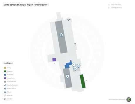
Santa Barbara Airport Information
-
Airport Address:
500 Fowler Rd, Santa Barbara, CA 93117, United States -
Official Website:
http://www.flysba.com/ -
Contact Number:
(805) 967-7111
SBA Contact Information
-
Name:
HENRY THOMPSON -
Address:
601 FIRESTONE RD -
Telephone:
(805) 967-7111
Santa Barbara Airport
Santa Barbara Municipal Airport (SBA) is ideally located in Santa Barbara, California, and serves as a convenient gateway to the scenic Central Coast. This airport is supported by airlines such as American Airlines, United Airlines, Alaska Airlines, Southwest Airlines and Delta Air Lines, providing direct flights to major destinations such as Dallas/Fort Worth, Denver, Seattle, Seattle, San Francisco, Phoenix, Los Angeles and Salt Lake City. This network provides easy access to more domestic and international routes.
The SBA terminal offers passengers a comfortable and efficient travel experience, including a variety of restaurants with local flavor, retail stores for souvenirs and last-minute shopping, and car rental services to explore the region. Free Wi-Fi throughout the terminal ensures travelers can stay connected. Convenient parking is available near the terminal for both short and long term car rentals. The combination of essential services and direct connectivity makes SBA a key hub for residents and visitors to Santa Barbara and the surrounding area.
Santa Barbara Airport Weather 07/23/2026
Weather Forecast
Tonight
66
Mostly Clear

Thursday
88
Sunny
Thursday Night
66
Mostly Clear

Friday
85
Increasing Clouds

Friday Night
65
Mostly Cloudy
Saturday
83
Sunny
Saturday Night
66
Mostly Clear

Sunday
84
Mostly Sunny

Sunday Night
65
Partly Cloudy
Monday
83
Mostly Sunny
Monday Night
63
Mostly Clear
Tuesday
81
Mostly Sunny
Tuesday Night
63
Mostly Clear