Honolulu Airport (HNL) | Terminal maps | Airport guide


Honolulu Airport Terminal Guides
View All HNL Guides-
HNL Airport Terminal 1
Open Guide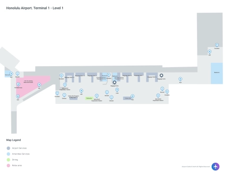
-
HNL Airport Terminal 2
Open Guide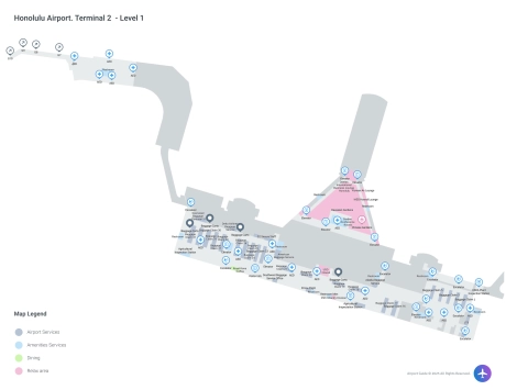
-
HNL Airport Terminal 3
Open Guide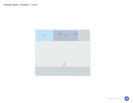
Honolulu Airport Information
-
Airport Address:
Daniel K. Inouye International Airport 300 Rodgers Blvd Honolulu, HI 96819 -
Official Website:
http://hawaii.gov/hnl -
Contact Number:
(808) 836-6411
HNL Contact Information
-
Name:
ROY SAKATA -
Address:
300 RODGERS BLVD. #12 -
Telephone:
(808) 836-6533
Honolulu Airport
Honolulu's Daniel K. Inouye International Airport (HNL), located on the island of Oahu, is the primary aviation gateway to Hawaii and a major hub for travel between the U.S. mainland, Asia, and the Pacific islands. Serving as a vital link for both tourists and local residents, it effectively manages large volumes of passengers with its extensive facilities and amenities.
The airport is well-equipped to handle a diverse array of traveler needs. It features three main terminals: the Interisland Terminal, the Overseas Terminal, and the Commuter Terminal, which are connected by a combination of walking routes and the "Wiki Wiki" shuttle buses that are free and frequent.
For passenger convenience, HNL offers a range of dining options, from fast food to local Hawaiian cuisine. Shopping opportunities are abundant with stores selling everything from souvenirs and travel essentials to luxury goods. The airport also provides several lounges, including airline-specific clubs and a shared lounge accessible to passengers of different airlines for a fee or via membership programs.
Accessibility is a priority at HNL, with services like wheelchair assistance, accessible restrooms, and visual paging for hearing-impaired travelers. Families traveling with children can benefit from family restrooms and a nursing room.
Connectivity is facilitated through free Wi-Fi available throughout the airport, helping passengers stay connected. For those needing a quieter space to work, there are designated areas that provide a more private environment.
Transportation options from the airport include public buses, shuttles, taxis, and app-based ride services. There is also ample parking for those who choose to drive.
Overall, Honolulu's airport combines functionality with the aloha spirit, ensuring a pleasant transit experience for all visitors.
Honolulu Airport Weather 08/03/2026
Weather Forecast
This Afternoon
86
Isolated Showers and Breezy

Tonight
76
Scattered Showers and Breezy

Monday
87
Scattered Showers and Breezy
Monday Night
76
Scattered Showers
Tuesday
87
Scattered Showers
Tuesday Night
77
Scattered Showers

Wednesday
88
Scattered Showers
Wednesday Night
77
Scattered Showers

Thursday
88
Scattered Showers
Thursday Night
78
Scattered Showers and Breezy
Friday
88
Scattered Showers and Breezy

Friday Night
76
Scattered Showers and Breezy
Saturday
88
Scattered Showers and Breezy